During my 1972 summer trip to
Europe,
Switzerland was another destination. In this case it was the
Lauterbrunnental (
Lauterbrunnen valley) in the
Bernese Oberland in central Switzerland. The photos I took show you what the area looked like at that time. Since then, I've heard that the glaciers are receding due to the changes in the global weather patterns. I stayed with a farm family above the village of
Lauterbrunnen (
elevation 795 meters). I arrived on a Friday. The Saturday was the first full day in the country. In the scene above you see the
Staubbach falls which drop
297 meters from the edge of the cliff above. By the time the water hits the ground below it is like a mist, hence the name.

On the Sunday I went on a long hike further up the valley to a cable car station at
Stechelberg (
960 meters elevation). From there it was by cable car (
Seilbahn) to the village of
Muerren where the next station was located (
1650 meters elevation). Then it was a trek up the
Schilthorn mountain to a cable car station at Birg. I had originally wanted to hike all the way up to the summit at
2,973 meters but decided against it due to time limitations. The photo above shows the scene on the walk from
Lauterbrunnen to
Stechelberg.

From Muerren and on the way up it is possible to see various mountains such as the
Jungfrau (
4,158.2 meters), the
Moench, the
Eiger and the
Breithorn. As the following images will attest, its a very scenic view from this height.


A view looking south where the elevation is even higher. There are glaciers behind these mountains. The image below was shot near the ski lodge. The area was used as a setting for the
James Bond film called
"In her Majesty's Service." The entire cable car system and stations was built for the movie by the studio and then given to the Swiss when the filming was done. The filming took place a couple of years before I arrived to view this scene.


Above is the view from the cable car station at
Birg looking across the
Lauterbrunnen valley toward the
Maennlichen in the foreground at
2,343 meters in elevation. Below is another view looking toward the south.


On the way back down to
Muerren, I took this shot of a group of farm buildings at
Sonnenberg. Monday it was time to return to
Interlaken by the narrow gauge railway and then on to
Basel and into
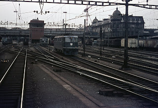
Germany. Two two photos below show the train (regular gauge) passing through the town of
Thun on
Thunersee and finally the main railway station in
Basel,
Switzerland before continuing on to Germany. I planning the itinerary I ended up crossing destinations off my list just because there wasn't enough time or money to see them all. Time was probably the biggest factor. I was only in Europe for seven weeks and had a two month student
railpass to get about ($120 at the time through the
Germanrail office in
NYC). The visit here and to
Salzburg set my interest in mountainous environments. Is it any wonder? I hope you have enjoyed the photos! Feel free to ask any questions. - V


 During my 1972 summer trip to Europe, Switzerland was another destination. In this case it was the Lauterbrunnental (Lauterbrunnen valley) in the Bernese Oberland in central Switzerland. The photos I took show you what the area looked like at that time. Since then, I've heard that the glaciers are receding due to the changes in the global weather patterns. I stayed with a farm family above the village of Lauterbrunnen (elevation 795 meters). I arrived on a Friday. The Saturday was the first full day in the country. In the scene above you see the Staubbach falls which drop 297 meters from the edge of the cliff above. By the time the water hits the ground below it is like a mist, hence the name.
 On the Sunday I went on a long hike further up the valley to a cable car station at Stechelberg (960 meters elevation). From there it was by cable car (Seilbahn) to the village of Muerren where the next station was located (1650 meters elevation). Then it was a trek up the Schilthorn mountain to a cable car station at Birg. I had originally wanted to hike all the way up to the summit at 2,973 meters but decided against it due to time limitations. The photo above shows the scene on the walk from Lauterbrunnen to Stechelberg.
 From Muerren and on the way up it is possible to see various mountains such as the Jungfrau (4,158.2 meters), the Moench, the Eiger and the Breithorn. As the following images will attest, its a very scenic view from this height.


 A view looking south where the elevation is even higher. There are glaciers behind these mountains. The image below was shot near the ski lodge. The area was used as a setting for the James Bond film called "In her Majesty's Service." The entire cable car system and stations was built for the movie by the studio and then given to the Swiss when the filming was done. The filming took place a couple of years before I arrived to view this scene.

 Above is the view from the cable car station at Birg looking across the Lauterbrunnen valley toward the Maennlichen in the foreground at 2,343 meters in elevation. Below is another view looking toward the south.

 On the way back down to Muerren, I took this shot of a group of farm buildings at Sonnenberg. Monday it was time to return to Interlaken by the narrow gauge railway and then on to Basel and into Germany. Two two photos below show the train (regular gauge) passing through the town of Thun on Thunersee and finally the main railway station in Basel, Switzerland before continuing on to Germany. I planning the itinerary I ended up crossing destinations off my list just because there wasn't enough time or money to see them all. Time was probably the biggest factor. I was only in Europe for seven weeks and had a two month student railpass to get about ($120 at the time through the Germanrail office in NYC). The visit here and to Salzburg set my interest in mountainous environments. Is it any wonder? I hope you have enjoyed the photos! Feel free to ask any questions. - V


2 comments:
Wonderful pictures. Must be lovely to spend some time in the little village on the third picture and wake up in the morning with this beautiful view!
Thanks for sharing.
Hugs
Jon
Thank you! I was 18 at the time nearing my 19th birthday. It was a great experience though there were times that I would have loved to have my brother along, so he could share in the experience. I was staying in a small chalet above the village of Lauterbrunnen and saw the Jungfrau (mountain) when looking out of the window in the morning. The view was not to be missed! - V
Post a Comment