Now that you've had a sampling of photos from the start of the
Admiralty Point Trail, here are some more, lots more, but even these are not all of the images taken on August 28th. They will certainly give you an idea what can be seen along the way. I like the way the sunlight illuminates the trail beckoning us further. Some of the trees are tall and ferns make up a common undergrowth.


I managed to get a good shot of a
spider web caught in the sunlight. I did try to get a few more but the light breeze blowing at the time caused the shrub to move too much to get the camera to focus.
Holly bushes can be seen here and there as the image following that of the web will attest.


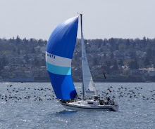
The ship, an
oil tanker, was anchored in
Indian Arm where it meets
Burrard Inlet. You could hear the motours from the ship from the trail on shore. In places along the trail the noise was loud and out of place for the setting. There is an oil refinery along Burrard Inlet on the north shore!


I hike down the 100 meter trail to
Admiralty Point from the main trail and here are a few images taken along the way. The sunlight in the opening invites us to check out the point. These roots on the trail were interesting enough to photograph. What do you think?


The photo above shows
Cod Rock where people were fishing from
crabs and
Rock Cod. I did take a few photos there but mored on to quieter places with less activity.


I also took a series of images of the area along the west side of
Indian Arm from
Burrard Inlet on north.


There's a plaque at
Admiralty Point which states that the property there is federal land leased to the city of
Vancouver for 99 years. That lease will be up soon, so what then? The land includes
Admiralty Point and
Burns Point further to the east on the north side of
Burrard Inlet.


In the image below you see me resting my feet at
Admiralty Point with the plaque at one of my feet.


Back at the main trail I tried to get in a few shots of a
Douglas' Squirrel I saw on the trunk of one of the large
coniferous trees. The two of the squirrel weren't very clear but here they are anyway. Its a great big tree too!


Then it was on to
Burns Point. Shortly after getting underway again I saw some
fungi growing on a stump. There is a series of images of them.


After the fungi photos it was off again further up the trail to
Burns Point with the odd view out on to
Burrard Inlet. It was an odd place to see a
Hydrangea bush but I loved seeing the colour just the same.


The trail even gave us some colourful surprises as the next series of images will attest.


The early signs of
autumn were present if you looked carefully. Check out the photo above and the close-up below.

 Ferns
Ferns were everywhere. There's a shot of a grouping above and a close-up below.


Here is a series of images taken of an overturned conifer tree with roots exposed.
Conifer trees are shallow-rooted and easily blown over in a severe wind storm such as we had late in 2006.


There are more very tall trees in this area just suitable as a perch for
bald eagles which frequent the area.


There is more colour, such as
fireweed above, and then I found more
fungi growing on a fallen tree trunk as seen below.


Then there's the odd
stump seen with or without
fungi and suitable places for
wildlife to feed or to sun themselves.
Burns Point is just a rock high up above
Burrard Inlet on the north shore east of
Indian Arm. A series of photos taken at the point follows, including two with a trig point. I have seen the odd one here and there in this area. The high voltage hydro-electric lines run across the water and there's a constant humming or chirping coming from them.


Again the beginnings of
autumn colour could be seen if you looked carefully. I hope you've enjoyed these photos taken on August 28th while I was hiking the
Admiralty Point Trail. Feel free to ask any questions. Aside from checking out such photos, this is how we learn and then have even more questions to ask! - V

 Now that you've had a sampling of photos from the start of the Admiralty Point Trail, here are some more, lots more, but even these are not all of the images taken on August 28th. They will certainly give you an idea what can be seen along the way. I like the way the sunlight illuminates the trail beckoning us further. Some of the trees are tall and ferns make up a common undergrowth.
 I managed to get a good shot of a spider web caught in the sunlight. I did try to get a few more but the light breeze blowing at the time caused the shrub to move too much to get the camera to focus. Holly bushes can be seen here and there as the image following that of the web will attest.


 The ship, an oil tanker, was anchored in Indian Arm where it meets Burrard Inlet. You could hear the motours from the ship from the trail on shore. In places along the trail the noise was loud and out of place for the setting. There is an oil refinery along Burrard Inlet on the north shore!

 I hike down the 100 meter trail to Admiralty Point from the main trail and here are a few images taken along the way. The sunlight in the opening invites us to check out the point. These roots on the trail were interesting enough to photograph. What do you think?


 The photo above shows Cod Rock where people were fishing from crabs and Rock Cod. I did take a few photos there but mored on to quieter places with less activity.
 I also took a series of images of the area along the west side of Indian Arm from Burrard Inlet on north.

 There's a plaque at Admiralty Point which states that the property there is federal land leased to the city of Vancouver for 99 years. That lease will be up soon, so what then? The land includes Admiralty Point and Burns Point further to the east on the north side of Burrard Inlet.

 In the image below you see me resting my feet at Admiralty Point with the plaque at one of my feet.


 Back at the main trail I tried to get in a few shots of a Douglas' Squirrel I saw on the trunk of one of the large coniferous trees. The two of the squirrel weren't very clear but here they are anyway. Its a great big tree too!

 Then it was on to Burns Point. Shortly after getting underway again I saw some fungi growing on a stump. There is a series of images of them.


 After the fungi photos it was off again further up the trail to Burns Point with the odd view out on to Burrard Inlet. It was an odd place to see a Hydrangea bush but I loved seeing the colour just the same.


 The early signs of autumn were present if you looked carefully. Check out the photo above and the close-up below.
 Ferns were everywhere. There's a shot of a grouping above and a close-up below.
 Here is a series of images taken of an overturned conifer tree with roots exposed. Conifer trees are shallow-rooted and easily blown over in a severe wind storm such as we had late in 2006.


 There are more very tall trees in this area just suitable as a perch for bald eagles which frequent the area.


 There is more colour, such as fireweed above, and then I found more fungi growing on a fallen tree trunk as seen below.


 Then there's the odd stump seen with or without fungi and suitable places for wildlife to feed or to sun themselves. Burns Point is just a rock high up above Burrard Inlet on the north shore east of Indian Arm. A series of photos taken at the point follows, including two with a trig point. I have seen the odd one here and there in this area. The high voltage hydro-electric lines run across the water and there's a constant humming or chirping coming from them.


 Again the beginnings of autumn colour could be seen if you looked carefully. I hope you've enjoyed these photos taken on August 28th while I was hiking the Admiralty Point Trail. Feel free to ask any questions. Aside from checking out such photos, this is how we learn and then have even more questions to ask! - V